The word “adaptation” means many different things to different people depending on where you live and how you earn your living. Farms, fisheries, transportation services, hospitals, manufacturing facilities, and schools are just a few of the sectors that need to plan for oncoming change. For those who live or work near the coast, the effects of climate change are already visible and, in many cases, planning has yet to keep pace. While it’s not possible to “future-proof” entirely against natural hazards, proper advance planning can result in far more security.
 For Caribbean islands that rely heavily on tourism, protecting airport runways and access roads, ports, marinas, and seaside businesses and infrastructure are all important parts of the master planning process. So is protecting the natural resources and critical infrastructure that support the countries’ resident population. The questions that need to be asked and answered include: how vulnerable is coastal infrastructure such as hospitals and refineries? What might be the economic losses should a major road, airport, port, or resort become unusable? In planning for shoreline protection, there is a balance to be negotiated between how much risk a property owner or government agency is willing to assume and how much they are willing to spend to protect an asset.
Smith Warner International’s Director of Projects Chris Hylton explains, “We incorporate resilience into every design. All our designs take into account sea level rise. For the client, for the most part, it’s the cost of construction that’s the driving force. Sometimes, the client is willing to compromise on the robustness of the design to meet their budget.”
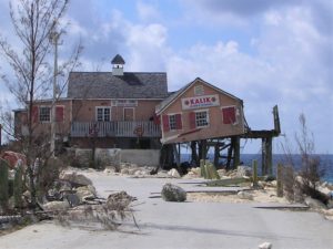
 The design of any coastal project must consider not only sea level rise but also the possibility of increasingly intense storms with strong waves, storm surge, high winds, and flooding from different angles. “What we’ve found based on experience,” Chris continues, “Is that a ‘one in 50’ is the best balance between meeting the design objectives and the cost.” A “one in 50” (or 1:50) means that the likelihood of a such a major storm occurring is just once in 50 years.
Dr. David Smith, Smith Warner International’s co-founder and now Director of its Quality and Innovation, gives the example of a marina with walls. “Say the jetties are built with the crest at a certain elevation, and say you want it work 50 years into the future. You really should do an estimation of what the sea levels are going to be 50 years in the future and account for that in your design.”
Tricky Calculations
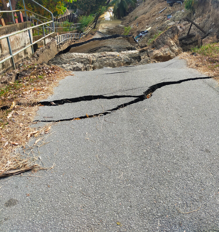
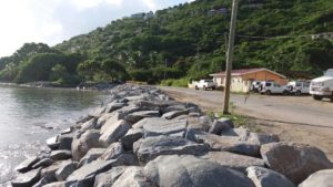
The math may seem straightforward: If sea level is rising a certain number of centimeters per decade, then a structure built to withstand the kind of storm that makes landfall only once in that many decades should be built the same amount or higher. But that is not the case at all. As sea level rises, the deeper water allows larger waves to attack the shore and batter the structures that protect it. That’s based on the physics that forces waves to break at a certain height-to-depth ratio as they approach the shore. But larger waves also move faster and pack more energy, thus increasing the strength of the attack. Such calculations are key in determining the size of armour stone in boulder structures such as breakwaters and revetments.
While the 1:50 “return period” (meaning how often a major storm would be likely to occur) may be the new standard, Smith Warner is seeing Caribbean governments choosing to build for the “one in a 100 year” storm. With hurricanes becoming more intense, longer lasting, and potentially more frequent, the definition of the return period itself is changing. For that reason, data collection and analysis are more important than ever. Chris Hylton explains, “It’s more important (in the current climate) to have a running database and update the database as we do, whether it be in hydrology (rainfall data for drainage design) or wave height. I’ve done a few projects between 2010 and now, where a 1:25 return period easily became a 1:10.” He continues, “We design our structures for hurricane wave forces and what we’ve found is between 2017-2019 with the intensity and frequency, we’ve adjusted the wave heights associated with the return period.”
Planning Ahead
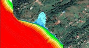 In looking forward, Dr. David Smith advises, “One of the first things countries have to do is produce up-to-date hazard mapping. That’s an absolute must, and it should be supported by proper, accurate survey information. We’ve called for many years for countries to try to get hold of LIDAR and have topographic and bathymetric surveys done so that you have really good, detailed delineation on which to do storm surge modelling.”
David points to Barbados as an example of a Caribbean country that has been proactive in its adaptation planning and in delineating coastal hazard zones. Considering various scenarios of global mean temperature increase and sea level rise results in a range of possible hazard zone scenarios. “If you were a forward-thinking country, you would want to relocate your critical infrastructure out of these zones,” David concludes. “It’s not a single line in the sand. It could be a range of lines depending on which pathway the world chooses to follow. The end game could be more severe or less severe.”
The problems that many Small Island Developing States and countries with large coastal zones will face is that once this range of hazard lines is drawn, they will find that many of their infrastructure assets already are located within these areas. That raises an entirely new analysis and range of trade-offs: Does the government abandon these lands? Purchase them? Modify zoning to raise structures to buy themselves more time? The answers to these questions form the basis for the Coastal Zone Master Plans that every coastal nation will need to explore sooner rather than later.